 Live Music Archive
 Librivox Free Audio
 Metropolitan Museum
 Cleveland Museum of Art
 Internet Arcade
 Console Living Room
 Books to Borrow
 Open Library
 TV News
 Understanding 9/11
tv News4 Today NBC October 29, 2012 6:00am-7:00am EDT
6:00 am
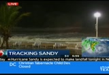
roads. >> these are live pictures from ocean city, maryland, where the mayor ordered a mandatory evacuation of parts of that coastal community. good morning and welcome to "news 4 today." i'm eun yang. >> good morning. i'm aaron gilchrist. it is monday, october 29th, 2012. we're tracking hurricane sandy. all major public school systems in d.c., maryland, and virginia are closed this morning. the same goes for most private schools right now. the federal government also cled. all nonessential employees should stay at home. most major local governments also closed in maryland and virginia along with the d.c. government, and metro shut down all rail services, all bus services for the first time since 2003. marc, vre also closed today. and amtrak says its northeast corridor is shut down. a complete list for you at the bottom of your screen and at nbcwashington.com. >> let's che in with storm team 4 meteorologist tom kierein right now. as you take a look outside at reagan national airport, almost
6:01 am
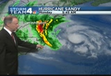
all of the flights here at the local airports at reagan national, dulles, and bwi are cancelled. be sure to check your airline as you head out the door. >> breedsy and light rain already falling and getting heavier across parts of our immediate area right now. some of the places that are more to the east are being hit particularly hard already at this hour. now we've got storm team 4 meteorologist tom kierein to break it down. >> you can see the extent of this storm. it's huge. it's about 1,000 miles wide. it's continuing on a track that is now taking aim at our atlantic seaboard. and way out ahead of it hundreds of miles, we already have very heavy rain bands that are moving in. here's the latest track. this came out about an hour ago. it's going to be updated about 8:00 this morning. we'll get that to you immediately. and the latest track is taking it ashore somewhere from the central jersey shore to just south of ocean city. anywhere in this landfall zone. by then, a very small post tropical low.
6:02 am

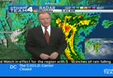
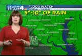
the storm is going to affect all the way to new england. right now getting heavy rain right across the bay. and now that is moving into southern maryland now into our eastern suburbs, prince george's county getting a band of heavy rain. that's going to be continuing to track west and sweep right through the metro area, continuing to sweep farther west and all the way out into the mountains. in some parts of southern west virginia, they're getting snow. a blizzard warning out there. much of the mountain region from western maryland to west virginia. 6 to 12 inches of snow throughout the day into tomorrow. 5 to 10 inches of rain these counties in green, northern virginia and maryland. in addition, gusts of wind to 70 miles an hour. all these in color are the high wind warning from this morning all the way into tuesday morning. that's when we're going to have
6:03 am

the power outages, tree limbs and maybe even some trees getting toppled from those very strong winds. hour by hour, increasing rain, increasing wind throughout the day. now to traffic with danella. >> between westmoreland street and haycock road, all lanes blocked. bethesda, high standing water. it closes river road and little falls parkway. it's start to go get tricky if you're commuting now. aaron and eun, back over to you. we have full team coverage of hurricane sandy. right now we're keeping a close eye on the coast for you, starting to feel the full force of this storm. news 4's erica gonzalez is live on rehoboth beach. conditions are deteriorating
6:04 am

fast. >> reporter: aaron, you just said that, and we got a great big gust going this way. it's so different than any other hurricane that i've covered because it's cold out here. take a look at the waters now. so choppy. the are the waves are out on the bort walk. you do not need to be on the roads. it is now illegal for you to be on the roads. if you are caught on the roads, you'll be fined more than $100 for the first offense. $200 for the second. you could spend up to 30 days in jail for anything over that. you don't need to be out here. 45 mile an hour wind gusts. by later this afternoon, you could be experiencing hurricane force winds. anything that is left outside needs to be brought in as soon as possible because anything that is flying at you at more
6:05 am

than 75 miles an hour cannot be stopping. you cannot get out of the way of something like that. aaron, eun, back to you. >> erica gonzalez at rehoboth beach for us. thank you, erica. >> 6:05 now. already pepco is reporting nearly 3,000 customers in our area without power. the company says it's as prepared as it can be to g the lights back on to its customers. hundreds of utility crews from across the country are in our area to help pepco, but they may have to wait out the storm like the rest of us. news 4's tony tull is live at the fairgrounds in gaithersburg. are they ready to go? >> reporter: yeah, they are. they're staying at local hotels in gaithersburg. a lot have to wait until sandy calms down or passes and get in the trucks and raise the boom and get in their buckets and start making repairs. pepco last week put out a mutual aid request to some of the
6:06 am

neighboring regions. guys, was it ever answered. you're looking at power trucks from north carolina power company. take a look to the left. those are alabama power company trucks. if you look down all the way to the left to the other side of the fairgrounds, you can see power trucks from arkansas. hundreds of trucks. quite a scene here at montgomery county fairgrounds, to see how many other power companies from the region came out to help. we want to reiterate if you do have power troubles, we have to wait a little while so these guys can operate from a semi safe position. give them time until sandy is able to calm down. that is going to play into a big factor on these crews tting out. if you take a look at the other side of the fairground, about two minutes. divid guys getting in their truck and raising the boom up. we're going to bring you an update before the show is over. just to let you know some power companies saying they have some
6:07 am

outages. interesting to see if these guys are heading out to help. going to chat with them and bring you an update on the crews coming to help us out here as they gear up for the power out ge as. >> dominion virginia says it has commitments from about 2,000 outside crew members to help restore power after sandy moves out of town. sandy is impacting the election l sas well, which is j eight days away. president obama has cancelled campaign events in virginia and ohio to monitor the storm here from washington. he has also cancelled an appearance tomorrow here in colorado. mitt romney scrapped plans to spend yesterday in virginia. instead, he joined running mate paul ryan in ohio. the republican presidential nominee campaigning again today in ohio. he'll stop in iowa and wisconsin after that. the storm has also put early voting in maryland on hold. those hoping to cast their
6:08 am

ballots before next week's election will have to wait at least a day as governor o'malley cancelled all early voting. early voting started on saturday. a lot of people lined up to get it done before the storm. voting was supposed to end on thursday, but it may be extended. complete coverage of hurricane sandy on our website, nbcwashington. nbcwashington.com. while you are online, you can sign up with breaking news and weather alerts. new this morning, a woman faces charges accused of falsely reporting her car was stolen with her three young children inside, triggering an amber alert. overnight, prince george's county police cancelled the amber alert for the children. they believe the woman told police the children were in the car so she could get a faster police response. police found the car in southeast washington. the woman called the police from a gas station in seat pleasant. the car was stolen down the street on central avenue. >> time is 6:08. coming up, what kind of trouble hurricane sandy is
6:09 am

causing for air travelers and why it could get a lot worse over the next 48 hours. plus storm team 4's tom kierein is back with where we're seeing heavy wind and rain anncr: it's said that character is what we do... when we think no one is looking. mitt romney: believe that they are victims. anncr: mitt romney thought no one was looking when... he attacked forty-seven percent of americans. his companies shipped jobs overseas. his plan cuts millionaires' taxes, but raises yours. he'll voucherize medicare... and make catastrophic cuts to education. so remember what romney said... and what his plan would do. president obama: i'm barack obama and... i approve this message.


6:12 am

this is a live look at rehoboth beach, delaware. where the waves have reached the boardwalk already. >> 45 mile an hour winds that are coming through that area. erica has told us this morning the governor has said no one is allowed to drive in the state of delaware at this hour. rehoboth beach has been
6:13 am

evacuated completely with the exception of a few news crews. our guys are going to have to get off the boardwalk and move to higher ground as the storm intensifies. also,he storm has already forced more than 7,000 flights to be cancelled. that's according to the site flight aware. reagan and dulles do plan to stay open, but you're urged to contact your airline before you go to any airport anywhere on the eastern seaboard because thousands of flights have been cancelled. >> it can probably be the same situation for tomorrow as well. >> let's check in with storm team 4 meteorologist tom kierein, who is following sandy and figuring out where it is going to hit and how it's going to affect us. tom? it's going to affect a huge area from virginia to new england. right now time for weather and traffic on the ones. the heaviest rains from sandy crossing the bay, getting very close to washington. we've got cold air wrapping in, and it's changed to snow in southern west virginia, south west virginia this morning, and
6:14 am
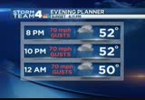
the heaviest rains, red and orange crossing the bay. this is a huge area of heavy rain, about 50 miles wide, and it extends from pennsylvania all the way down to southern virginia. it's advancing west and going to be coming right into washington over the next hour. right now prince george's county getting the heavy rain and the rest of southern maryland. steady rain through 8:00 a.m. in the mid-50s. winds starting to gust around 40 by noontime. 60 mile an hour gusts by 6:00 p.m. with the rain continuing. this evening, 70-mile-per-hour gusts off and on from 8:00 p.m. all the way to after midnight. a look at the seven-day outlook and a look at the warnings in ten minutes. now a look at traffic with danella. >> still seeing orland street shut down in both directions between westmoreland street and haycock road due to a fire. let's talk about accidents. if you to get on the roadway,
6:15 am

i-95 southbound just past 234. i have a crash as you head southbound, the left lane is blocked. and slick conditions as you continue i-95 southbound seeing another accident. this is in the quantico area. again, this accident blocking two of your left lanes. if you are heading out, please use caution. i'm seeing fenders pop up. sandy expected to cause problems from virginia to new england. coming up, a live report from new jersey.


6:18 am

[monotone] she says, "switch to progressive and you could save hundreds." call or click today. welcome back at 6:18. sandy is too much for wall street to handle today. the new york stock exchange is closed today. it's the first time it's shut down since 1985 when hurricane gloria hit the big apple. new jersey's governor has declared a state of emergency and suspended all public transportation. danielle leigh is live from cape may-on-. what's the latest? >> reporter: good morning, aaron. we are getting drenched in this steady downpour. if you take a look at the ground, the rain alone is causing significant puddling,
6:19 am

and that's not what the emergency officials are worried about. it's the rising tides on the beaches behind me, up to eight feet. not too long ago, we saw patrols making sure people are not outside. i haven't seen anyone out this morning walking around. people are heeding orders to evacuate or stay used. many people are hoping that boarded up windows like this are going to hold as this storm gets going. emergency officials say you're going to see power out anages. i'm danielle leigh. and our neighbors in rehoboth beach already feeling the impact from sandy. roads closed, leaving some drivers stranded. here you can see a state trooper who ran into high water on route 1, a major roadway there. had to abandon his cruiser on the indian river inlet. route 1 a major route along the
6:20 am

delaware shore. this is a great reminder not to drive across high water over the next couple of days, and you will as this storm passes. if you rely on metro to get around town, you are not going anywhere for a few days. metro shut down all rails and bus service today. a spokesperson for the transit system says metro will probably be closed for at least part of tomorrow. the last time metro had such an extensive shutdown was back in 2003 during hurricane isabelle. d.c. residents gearing up for sandy's impact. that includes neighborhoods prone to power outages and flooding. news 4's megan mcgrath is live in the bloomingdale section of the city. >> reporter: good morning, eun. the folks in bloomingdale, they know flooding all too well. they've had a real problem in recent months, and that's just with regular storms, not the kind of thing we're expecting here with sandy. they're trying to take precautions. this is windows cafe here on rhode island avenue. they have had issues with flooding in the past. they have pulled out the sand bags. the hope is that, if they see
6:21 am

flooding once again, they can at least prevent it. take a look. it's raining harder. we still have not seen torrential downpours. so far, so good. the storm drains seem to be handling the rain that is falling at this point. they put a big effort out there this weekend to clear all the debris away from storm drains, get the leaves out of the way to make sure they don't have any clogs. they want these drains to be working at full capacity as soon as the real heavy rains begin. folks here crossing their fingers, hoping for the best, and keeping a very close eye on sandy and her movements. reporting live in northwest, megan mcgrath, news 4. back to you. >> megan, thank you. we want to get the latest on what sandy is doing and the rain that's already falling across our region. >> here's storm team 4
6:22 am
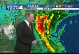
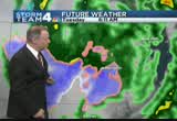
meteorologist tom kierein. the rain is about to move into the metro area. the first heavy rain bands from sandy now moving across the eastern shore, getting closer to us. sandy's latest track updated just about an hour or so ago, showing it's coming inland anywhere from the central jersey coast to just south of ocean city. doesn't matter now. it can come anywhere within this band and affect a huge region from virginia all the way to new england. it does look like it's making landfall perhaps after sunset around 9:00, 10:00 this evening. ahead of that, we're getting heavy rain around the bay in washington. snow in west virginia. and look at this heavy rain. these areas in orange and red, torrents of tropical downpours now just east of washington. it's going to be drifting west moving right into northern virginia, the district, and the rest of maryland. hour by hour throughout the day, we'll have this steady rain. the rain will increase. the wind will increase.
6:23 am

even higher gusts after that. storm team 4 four-day forecast, thankfully, things will be improving tomorrow. the rain diminishing and the wind diminishing, sunshine breaking out thursday, friday, and saturday with highs in the 50s. a lot of watches and rn warning. kim martucci joins us with the latest. >> let's start with something different. out in garrett county, 6:00 tonight until 6:00 tuesday. 6 to 12 inches of snow. that's 60 miles an hour. that spells right out commissions. we are now focused on a flood watch here, the heavy rain that tom has been showing you all morning. this is the rain bands from sandy. pivoting west. and because of the anticipated five to ten plus inches around the area, we're going to see water flooding, falling from the sky. after this happens, we'll be watching from the rivers after
6:24 am

the storm is long over rise. that's going to happen after the storm comes. that's when we have the frederick county monocacy river with the flood warning. just to recap that high wind warning as well. danella has the latest on your traffic. how's it looking out there? >> already seeing problems. let's start with a downed tree. this is in ellicott city. closing between route 40 and town and country boulevard. also, high standing water as you travel in bethesda, blocking river road at little falls parkway. please be aware of that. still seeing accident activity blocking the left lane as well as the left shoulder lane. aaron and eun, back over to you. >> we continue our special coverage of hurricane sandy. these are live pictures from plum island, massachusetts, where the surf has started to pick up. >> we'll also have a quick update from the world series. anncr: it's said that character is what we do...
6:25 am

when we think no one is looking. mitt romney: believe that they are victims. anncr: mitt romney thought no one was looking when... he attacked forty-seven percent of americans. his companies shipped jobs overseas. his plan cuts millionaires' taxes, but raises yours. he'll voucherize medicare... and make catastrophic cuts to education. so remember what romney said... and what his plan would do. president obama: i'm barack obama and... i approve this message.


6:28 am

president obama is urging everyone in sandy's path to prepare for the worst. he signed an emergency declaration for d.c. up and down the east coast, hundreds of thousands of people have been forced to pack up and get out. public transportation is shut down, and thousands of flights are cancelled. amtrak cancelled almost all of its service on the eastern seaboard. there will be no trains kwcomin to or from d.c. a quick peek into the world of sports this morning, and another tough loss for the redskins. steelers routed the skins 27-12 yesterday. robert griffin iii had one of the worst games of his young career. he had one touchdown and threw for just 177 yards. the skins now 3-5 on the season. they take on the carolina panthers next sunday. got him looking! and the giants have won it all.
6:29 am

>> major league baseball has new giants. the san francisco giants are the world champs. they completed a sweep of the detroit tigers last night with a 4-3 win in extra innings. >> two world series in three years, not bad. it is now 6:29. coming up, high tide kds be a problem along the coast this morning as hurricane sandy starts her trip to the west. we'll have live coverage from rehoboth beach.


6:33 am

has the potential to endanger up to 50 million people for days. that storm already shutting down beach communities, government, and major transit systems all along the east coast. good morning, everyone. welcome back to "news 4 today." i'm aaron gilchrist. >> and i'm eun yang. hurricane sandy is heading our way. ahead of the storm, pepco says about 700 additional workers from across the country are in our area right now to help the utility company restore any outages. metro shut down all rail and bus service today. all public school systems in d.c. and virginia are closed this morning. the federal government is also closed. all nonessential entities should stay home. you can find a complete list of closings running at the bottom of your screen and online at nbcwashington.com. >> as we take a look at the live city cam, rain is falling in the district already. a little wind for some folks. this is still not the main event just yet.
6:34 am
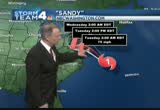
>> right. it's going to get worse. meteorologist tom kierein with the latest on sandy and more. tom? sandy has taken the dreaded left hand turn as we've been predicting. the last several days, sandy taking a curve to the left and coming inland. now it is just begun to do that the last couple of hours. after tracking northeast the last couple of days, it is now beginning to track off to the north and west. and way out ahead of it, it is producing some very heavy rain. right now the latest track for sandy, it will maintain category 1 strength. then become a very strong pos post-tropical low. tuesday at 10:00 a.m., it will likely be well inland at this point and probably coming ashore about 8:00, 9:00 tonight anywhere in this zone from central new jersey down to just south of ocean city. then passing just north of washington. that's going to be a time frame late tonight into tomorrow morning we're going to have the heaviest wind and a lot of the heavy rain out ahead of that
6:35 am

throughout the day. first of the heavy rain bands into areas south sweeping off to the west. will be coming our way all the way across northern virginia and the rest of maryland and through the morning. winds will increase hour by hour. 60-mile-per-hour gusts by 6:00 p.m. this evening we could have gusts to 70 miles an hour. that's when we'll have the wind damage and the power outages. time for a check of traffic with danella. a few incidents to warn you about right now. traveling in ellicott city here, rogers avenue closed between route 40 and town and country boulevard. that's because of a downed tree. heading over to bethesda, in anticipation for flooding, you're going to see river road blocked at little falls parkway. no flooding just yet, but just to be careful, that road is
6:36 am

blocked just in case. i-95 southbound approaching 234, still seeing accident activity blocking two of your left lanes. further southbound on i-95 in virginia approaching russell avenue, another accident there, also blocking two of your left lanes. >> danella, thanks so much. as sandy makes its turn for land, coastal communities are already getting hit hard with heavy wind and rain. our own erica gonzalez is in rehoboth beach, delaware, which could be right in the path of sandy's rainfall. erica, good morning to you. how are things now? >> reporter: storm surge is the biggest thing now. new information from meteorologist kim martucci, storm surge seven to nine feet. it has already breached the dunes and has made its way over to the boardwalk here in rehoboth beach. these waves are getting huge. and this is not even the tip of it.
6:37 am

as sandy makes what tom called that dreaded left turn, we're going to be seeing a lot more of this. rain is falling. and with the wind at 45 mile an hour gusts, we could be seeing those hurricane type winds coming in as early as this afternoon. there's the water coming in. we could be seeing that as early as this afternoon. we are remind by the governor of the state of delaware that residents need to be hunkered down in one of three shelters here in rehoboth if they can get to them as soon as possible. >> we've already seen flooding even though the storm is hundreds of miles away. this is going to be serious. if you live in an evacuation area, leave. it's that simple. if you're going to be sticking around because you're not in an evacuation area, you have to be prepared to be without power for a long time. >> reporter: here's the other thing. remember if you stay behind, you are potentially putting in jeopardy the lives of those first responders that have to
6:38 am

answer that call to see if they can come out to find you in these areas. another thing the governor of the state of delaware has issued is that nobody, as of 5:00 this morning, is allowed on the roads in the state of delaware. it is illegal now. and a reminder that nonessential employees do not need to be at work, and you don't have to be forced by your employers. governor saying, we'll deal with demands later. right now, stay home and be safe. now back to you. >> erica in rehoboth beach. erica, thank you. and first responders getting ready to spring into action too. one of them, the chantilly based virginia task force one. 80 people being mobilized. they'll find out where they're going later this morning. time 6:38. candidates making big schedule changes this morning because of hurricane sandy. how both are dealing with the crisis. anncr: seven-hundred-thousand jobs.
6:39 am

that's what the plan george allen supports... would cost our economy. newspapers called it "economically destructive." like allen's votes to give tax breaks to companies... that ship jobs overseas, his economic plan would... help big corporations, devastating the middle class. allen even voted against tax breaks for small businesses. virginia can't afford to go back to george allen. the democratic senatorial campaign committee... is responsible for the content of this advertising.
6:40 am

what mitt romney's tv ads say about women? or what mitt romney himself says? mitt romney: do i believe the supreme court... should overturn roe v. wade? yes. and it would be my preference that they, that they... reverse roe v. wade. hopefully reverse roe v. wade. overturn roe v. wade.
6:41 am

planned parenthood, we're going to get rid of that. i'll cut off funding to planned parenthood. anncr: no matter what mitt romney's ads say. we know what he'll do. president obama: i'm barack obama and... i approve this message.
6:42 am

welcome back. sandy isn't just a threat to humans, but to wildlife as well. a deer got caught in the surf in monmouth, new jersey. a barrier of rocks kept the deer from getting back on the beach. a resident did chase the deer to get it to safety. eventually, they came and tranquilized the deer and got it to safety. veterinarians are confident the deer can be nursed back to health. >> so a danger for anybody who might try to venture out in this storm is too severe. the potential is too severe to actually go out and put yourself at risk. >> everyone stay inside. stay put. meteorologist tom kierein with more on sandy. the near hurricane force winds about 50 miles off the coast. there's a buoy here about 50 miles east of ocean city, just reported a gust of 60 miles an hour, and there's an automated station here at assoteague that
6:43 am

reported a gust of 82 miles an hour. some of the automated stations can give you faulty information, but needless to say, a very strong wind field about to come ashore. very heavy rain about to move into the metro area. right now these areas of orange and red, torrents of rain. now southern maryland into the eastern suburbs, just now moving into washington, some of the heavier rain will continue to sweep off to the west to the rest of northern virginia. right now the gusts aren't too bad, about 25 locally. pax river had a gust up to 60. later on today, expect increasing wind and rain. gusts up to 60 by 6:00 p.m. this evening 70-mile-per-hour gusts maybe for an eight or nine-hour period, which is when we'll have the power outages and tree damage las well. more on that as well as the latest warnings in ten minutes. now the latest on traffic.
6:44 am

here's danella. >> many ggood morning, and than tom. in ellicott city, downed tree blocking between route 40. i-95 approaching 234 blocking the left lane as well as your shoulder lane. a live look of i-270, no accidents. but if you have to get on the road and make your way in the germantown area, heavy rain. accident free between germantown and rockville. as you connect to the beltway in maryland, not seeing any incidents as of right now. aaron, over to you. >> thank you, danella. hurricane sandy is not here yet, but she's already bringing d.c. to a standstill. right now all major public school systems -- d.c., maryland, virginia -- everybody closed this morning. same goes for most private schools in the area. the federal government is also closed. all nonessential employees should stay home today. most major local governments also closed in maryland and virginia as well as the district. and metro shut down all rail and bus service.
6:45 am

first time that's happened since 2003. marc and vre also closed. amtrak, no service along the northeast corridor. it is shut down today. you can find a complete list of closings at the bottom of your screen and at nbcwashington.com. one of those areas first responders could be responding to, news 4's melissa mol joins us live now with how that area is preparing. melissa, good morning. >> reporter: good morning, aaron. i don't know if it's easy for you to see, but the rain is definitely coming down much harder than it was at 4:00 this morning, 5:00 this morning, now around 6:30. it is nasty. the wind is picking up, and you can see the water much more choppy and rising fairly quickly. again, we are expecting high tide here around 8:30 this morning. remember if you have to go out today, acouple of inches of water can float a car. here in old town alexandria, low
6:46 am

lying area often has issues. we took a stroll down one of the main streets here a little bit ago earlier this morning. just to kind of show you how things are looking down here. flooding, of course, quite expected. we have street parking, some of the streets are completely clear because folks are not parking along the roads. we have computerized meters that are completely covered with garbage bags just to protect the inside from getting wet, and sandbags all over the place. if you're heading out today definitely be careful. we're going to be down here throughout the morning just keeping an eye on things. again, this water expected to rise quite a bit in the next couple of hours. it's going to be a nasty morning. live in old town alexandria, melissa mollet, news 4. let's join dan stessel on the phone from metro. dan, good morning to you. are you there? first, let me ask you a forward looking question.
6:47 am

we know that metro also was shut down today. what about tomorrow? when will you make the final decision? >> i wouldn't expect any decision on that until sometime this evening. probably the 6:00 or 7:00 hour. probably the same decision-making process we went through yesterday. that means in cooperation with the region as well as the federal government and with a briefing by the national weather service as to what to expect. once we have all of that information, we'll let our customers know what to expect for tomorrow's service and beyond. >> dan, during snowmageddon, 24 inches of snow on the ground, metro ran. how did you determine that metro would be shut down completely, especially when so many people are relying on public transportation and the experts are saying get off the roads? >> absolutely. the safest place to be is home in shelter and don't want to be out in this. we want the public to heed hub
6:48 am

lick warnings. we do know there's people who depend on the service even in the most severe conditions. the reason you see underground service suspended primarily was one of the things we heard from the commercial power companies. they were expressing concern about their ability to maintain service for the metro rail system. without third rail power, trains couldn't move, and we could end up in a situation where a train becomes stranded, and we're going to be tying up emergency responders in these extreme conditions coming out for something that really doesn't need to be happening at all. so that was really the key point that led us to the decision. like every transit agency from this region all the way up and including the new york metro area to suspend service for monday and possibly beyond that. >> dan stessel with metro, thank you, dan. the president warned everyone to prepare for the worst. he also signed an emergency declaration for d.c., which mayor gray requested. that will free up federal aid to
6:49 am

help the city respond to sandy. he says governments and first responders aren't the only ones to get people through the storm. >> one thing that americans do in times like this is pull together and help out one another. there may be elderly populations in your area. check on your neighbor. check on your friend. make sure they're prepared. if we do, we're going to get through this storm just fine. >> president obama will attend one campaign event today in florida before heading back to washington to monitor the storm. he is scrapping plans to go to a rally in ohio. mitt romney will campaign in three the battle ground states ohio, iowa, and wisconsin. he joined paul ryan in ohio. he took time out of his speech to reach out to americans impacted by sandy. and hurricane sandy is having a major impact on the financial markets as well. cnbc's jackie deangelis has the latest. jackie, good morning to you. >> many ggood morning. >> the u.s. markets will virtually be closed today due to
6:50 am

hurricane sandy. the nasdaq, and new york stock exchange will be closed through tomorrow. they were worried about the integrity of the markets and couldn't ensure the safety of employees trying to get to work. there will be electronic trading of oil, gas, and other energy contracts. the last time the markets were closed for a nonholiday event was after the terrorist attacks of 2001. and the last time they were closed for weather was september of 1985 because of hurricane gloria. and also keep in mind that about 65% of the oil refineries are in the path of the hurricane. delta airlines says that its jet fuel refinery in trainer, pennsylvania, is well prepared for the storm. we'll be keeping an eye on all of these areas. we've been showing you live
6:51 am
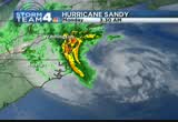
pictures from around the region as we're able to can assess cameras. you're looking at ocean city, maryland, as the surf has really started to beat up the beach there. we're told there are surges of up to four feet along the eastern seaboard. >> and tom kierein is here to tell us when sandy is making landfall and making a huge impact here. >> sandy making landfall in about 14 hours. already feeling the effects way out ahead of it. as i mentioned just a few moments ago, the winds just east of ocean city out of bowie, reported gusts of 60 miles an hour. that is accompanied by waves that are 23 feet high. that's just about 50 miles east of ocean city. all of this coming from huge hurricane sandy. sandy is going to get a surge of
6:52 am
energy merging with a polar jet coming across. winds will get back up to 60 to 70 miles an hour. it may come ashore just north of central new jersey to south of ocean city, moving inland as a post-tropical low. here comes heavy rain taking aim at washington and the metro area. heavy rains on the west side of the bay about to sweep through the metro area all the way to the west and across the rest of northern virginia. here's what it's look can like by 5:00 p.m. heavy rain and snow out of the mountains. tomorrow morning, a little bit of wet snowflakes flying through the air. chillier air inekt judjected in system when the polar air gets involved. the winds could be up to 70 miles an hour by 8:00 p.m. by 11:00 p.m., 60-mile-per-hour winds. by 1:00 a.m., still around 65 to 70 miles an hour. by 3:00 a.m., it will diminish. the rest of tuesday, the winds really weakening dramatically,
6:53 am
thankfully. unfortunately, we'll have that eight-hour period from 6:00 p.m. today all the way until about 3:00 a.m. tomorrow morning with winds gusting to around 70 miles an hour. and then the rest of the week, thankfully, we're going to get a drying trend on wednesday into thursday, friday, saturday, and sunday. highs in the 50s each day. we do have watches and warnings out. one of them incredibly is a blizzard warning, and kim martucci has details on that. >> that's right. 6 to 12 inches off to the west in garrett county. that starts tonight and goes until tomorrow night. around here, the flood watch in effect into tomorrow night, easily five to ten inches of rain. and a high wind warning. when do we get the gusts 60 miles an hour and greater? that's this afternoon into tonight. good news. southbound i-95 approaching 234, that earlier accident is gone. i-66, still very light volume. want to show you how the rain is
6:54 am

coming down. slick roadways. and over in i-95 in maryland to i-195, accident free. 6:54. we just heard from dan stessel with metro. if you rely on metro to get around town, you're probably not going anywhere for a few days. news 4's megan mcgrath live in northwest d.c. with more on that. >> reporter: good morning, aaron. we're here on rhode island avenue, and we're beginning rush hour although it's lighter than usual. what's strange is we're not seeing any metro buses. that's because metro service has been suspended, both bus service and rail service, until further notice. we caught up with some of the buses that were returning after their last runs last night. those buses went onto the lot, and that is where they're going to stay until this storm passes and until metro officials decide it's safe to resume service. report can live, megan mcgrath, news 4. conditions along the coast are quickly deteriorating. check out these waves crashing
6:55 am

over the sea wall along the boardwalk in ocean city, maryland. this was just minutes ago. news 4's erica gonzalez is live in rehoboth beach, delaware, where waves are also growing. erica? >> reporter: eun, good morning. surf is now seven to nine feet. sandy is a freak of nature at now 1,000 miles in diameter. she is huge, to say the least. water is quickly rising and approaching the boardwalk here in rehoboth beach. there is a driving ban in effect, and residents are hunkering down in shelters. take a look. the rain continues to come down, and with 45 mile an hour wind gusts, when this comes across your face, doesn't feel tooed go good. and the biggest difference between this and the other hurricanes my colleagues have been in, it's cold down here.
6:56 am

>> erica, thank you. that is "news 4 today." thank you for starting your day with us. >> the "today" show is next. we'll be back at 7:25 with the forecast and more local coverage as the d.c. area has a long day ahead.
6:57 am

in virginia, we know education means opportunity. that's why tim kaine expanded pre-k... championed higher ed and job training... helping make virginia "the best state to raise a child." but george allen has not made our kids a priority. as governor, he tried to cut funding for public schools. in washington, allen voted to end tax deductions for college tuition. and now, a budget plan that devastates k-12 classrooms-- all to pay for even more tax breaks for the wealthy. seiu cope is responsible for the content of this ad.

6:59 am

prand you're seeing that rightno quit in amnow.a... over five million new jobs. exports up forty one percent. home values... rising. our auto industry... back. and our heroes are coming home. we're not there yet, but we've made real progress and the... last thing we should do is turn back now. here's my plan for the next four years: making education and training a national priority; building on our manufacturing boom; boosting american-made energy; reducing the deficits responsibly by cutting where... we can, and asking the wealthy to pay a little more. and ending the war in afghanistan, so we can... do some nation-building here at home. that's the right path. so read my plan, compare it to governor romney's... and decide which is better for you. it's an honor to be your president... and i'm asking for your vote... so together, we can keep moving america forward. i'm barack obama and i approve this message.
421 Views
IN COLLECTIONS
WRC (NBC) Television Archive
  Television Archive News Search Service
Uploaded by TV Archive on
